Mystery van in Rossland key to our infrastructure's future

By Andrew Zwicker
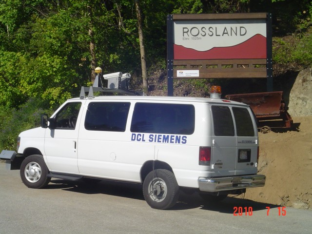
Have you noticed the white van with blacked-out windows that’s been cruising around town lately? The vehicle is covered in various technological odds and ends and has no identifying marks other than a subtle “DCL Siemens” decal on its back end. The van aroused my curiosity and prompted me to look into just what this mystery vehicle was all about.
As it turns out, the endless kilometres the mystery van has been clocking are all part of perhaps the most extensive study ever done on Rossland’s infrastructure in the Golden City’s 100-plus year history. The data generated through this exercise will provide some science to support decisions as to which roads need to be torn up, what sewer pipes will be replaced, what water lines need upgrading and which road is most in need of pot hole patching, repaving or complete reconstruction.
The entire project is all about making the city more efficient, timely and productive as it goes about the long, expensive and much needed upgrading of its aging infrastructure.
The van itself was on its first mission outside of its home province of Alberta, here to carry out an in depth pavement study of every piece of city blacktop in town.
Andy Munroe of DCL Siemens explained the tricked-out truck.
“Basically, what it has is five laser sensors in the front bumper. They actually fire from the bumper to the ground, measuring the actual distance from the bumper face to the surface of the road. On the two wheel track sensors on each side of the car there is what’s called an accelerometer. What that does is regulate the movement of the vehicle so it’s measuring the movement of the road itself, taking the movement of the van out of the equation. That gives you an IRI or International roughness index. That is based on a world scale so you can compare yourself to any other area in the world that uses this technology.
“While that is going on, we have two distress keyboards that rate the quality of the pavement. We do 13 different distresses that are occurring on the road as we drive down it. We log the start and stop points of the distresses in the pavement as we drive along. That could be transverse cracking longitudinal cracking, alligator type cracking. The types of distresses that occur on road surfaces. We are logging where they stop and start throughout the town.”
“At the same time, two high definition right-of-way cameras are capturing the entire right of way for the street so you have a video log of anything you have seen while doing the testing. That also ties into the GPS system on the roof so you can go back later on and mark on the GPS system anything that you can see be it signs, fire hydrants sidewalks and so on. Everything you see while you are driving you can pick up after the fact and log on a GPS map.”
With this information inputted into the City of Rossland’s GIS (Geographic Information Service) software along with layered data on the age and condition of water and sewer infrastructure below the road, the city will be able to run reports based on the desired outcome and get a list of priorities for rebuilding.
For example, if the City’s desired goal is to have the best upgraded water system, it can assign a higher priority to the age of the water system. The end result of this high tech process is some actual science to back up ideas of when and where roads and infrastructure should be replaced.
With tens of millions of dollars in infrastructure upgrades expected in Rossland over the next twenty years, this system, along with the pavement survey, will be critical in making the most of what will most likely end up being borrowed dollars.