Gerrymandering Feds: electoral boundaries cross the thin blue line
By Andrew Bennett
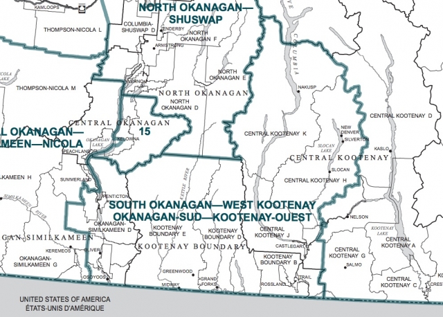
As the once-per-decade review process for federal riding’s comes to a close, including a hotly contested redistribution of the Southern Interior riding in which Rossland sits, the Federal Electoral Boundaries Commission submitted their proposal to the House of Commons without any significant changes.
“The final configuration of electoral districts throughout British Columbia has been greatly influenced by submissions and presentations from the public,” said John E. Hall, the chair of the three-person commission, despite the fact that the vast majority of public input given on the change to the Southern Interior was negative to the proposed changes.
Coun. Kathy Moore commented, “It’s another case of a level of government asking for input and ignoring it. Our input was ‘invaluable’ apparently,” she said, quoting commission secretary Susan McEvoy, but Moore passed this off as “irony.”
“It was strictly a political decision,” Moore said.
It is widely expected that the changes favour the election of a Conservative MP for the new riding, now called “South Okanagan-West Kootenay.”
The commission wrote:
“In drafting its proposal, the Commission was faced with the challenge of determining how to reconfigure the existing electoral district of Kootenay—Columbia, which demonstrated a variance of 16% below the electoral quota. The Commission determined that the only route of expansion was to the west. The proposal recommended crossing the Salmo-Creston (Kootenay Pass) and included the communities of Nelson, Salmo, Fruitvale and Montrose.
“Submissions encouraged the Commission to keep Nelson, Castlegar and Trail in one electoral district. However, such a combination would have resulted in an electoral district with numbers well above the electoral quota. The Commission also received submissions to keep Nakusp, Central Kootenay K, New Denver, the Slocan Valley and Central Kootenay H in the same electoral district. As well, the Commission was advised that the proposal had the effect of splitting communities adjacent to Kaslo and the north end of Kootenay Lake.
“The Commission adopted several of the suggestions and has reconfigured the Kootenay—Columbia electoral district, which now includes most of the existing district plus the City of Nelson and adjacent areas. The Commission configured a new electoral district named South Okanagan—West Kootenay that includes Trail, Castlegar, Fruitvale and Montrose in its eastern region. The central portion of the district comprises the Kootenay Boundary area, and the western region incorporates Osoyoos, Oliver and Penticton.”
The full report is available here.