Tales & legends of the Mountain Kingdom: Doing the dew dew Dewdney
By Allyson Kenning
I think it’s a fair statement to say that Rossland might not be what it is today without the efforts of an Englishman named Edgar Dewdney. Before he came along to build his eponymous trail, this area was a prime location for First Nations hunters and gatherers and was apparently well known for its huckleberry bounty. All that changed in the mid 1860s when gold in the southern part of what would eventually become British Columbia became the motivation for the British government to assert some kind of sovereignty over the land so that the in-ground riches would stay within British control. The best way to do this, the governor of the colony, James Douglas, decided, was to build a transportation corridor from the west coast to the Kootenays. A gold rush in Rock Creek in 1861 brought in a slew of American prospectors, as did a gold rush in Wild Horse Creek in 1864. Gold had been discovered at the mouth of the Pend d’Oreille River in 1854, which also meant an influx of American prospectors to the area as well, and even though the Hudson’s Bay Company had an outpost nearby at Fort Shepherd, the British powers that be couldn’t have anyone else too interested in what was going on in the Kootenays before they could protect it for themselves.
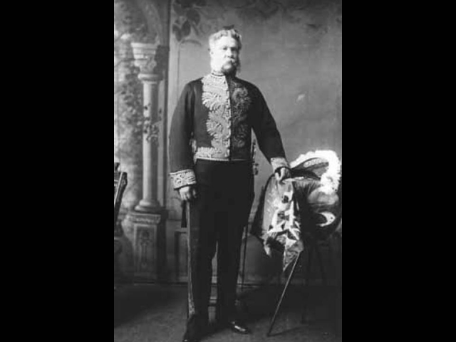
Enter Edgar Dewdney. He was born into an middle class Devonshire family in 1835. Middle class at that time meant that his family had land and servants, and enough money to educate Edgar at the University of Cardiff in Wales, where he trained in civil engineering. Rumours of gold and riches in New Caledonia (which eventually became British Columbia) reached him in London, and in 1859 a young Edgar found himself in Victoria eager to make his mark. He began his career in the colony working for Colonel Richard Moody, laying out the town and mainland capital, New Westminster.
His first crack at building roads came in 1860 when he partnered with Walter Moberly to build a mule trail from Hope to the mine-rich Similkameen Valley. This venture ended in a dispute over money, but the next year Dewdney won a contract to extend the Hope Trail to Rock Creek. He again partnered with Moberly. The road was to be twelve feet wide and built with wagon travel in mind, meaning it had to be appropriately graded and bridged. It wasn’t going to be possible, however, to build the road with those specifications: the costs got out of hand and the gold rush at Rock Creek turned out to be short-lived.
Between 1862 and 1864, Edgar surveyed and built roads in the Cariboo, got married, and settled down for a little while in New Westminster. And then when 1865 came around with the gold finds in Wild Horse Creek, just past Cranbrook, Dewdney would finally find the project that would be responsible for his legacy, the Dewdney Trail.
In the spring of 1865, Governor Frederick Seymour gave Edgar Dewdney the contract to extend the trail from Rock Creek to Wild Horse Creek. The trail would pass through the Boundary district from Rock Creek and wend its way through Grand Forks, Christina Lake, and over the Cascades before passing just south of Rossland’s city limits. It was four feet wide and designed for trains of pack horses, and in the words of Edgar Dewdney himself, “Between Christina Lake and the Columbia was one of the most difficult sections on account of dense undergrowth and fallen timber. To clear this out for the passage of the pack train, required many days hard labour.” Partnered with George Turner, Dewdney’s first choice was to avoid this route due to the difficult geography, thinking that finding a route through the Monashees to the Arrow Lakes, and then joining up with Kootenay Lake and the Kootenay River would have been easier, but it turned out that this more challenging route through the Cascades was more feasible. The team of labourers, which included some First Nations, some Chinese, and some former Royal Engineers, completed 291miles of four-foot trail in four months. In May of 1865, Dewdney and company arrived in Fort Shephard, where they began blazing the Wild Horse extension of the trail that would go through Salmo, Creston, Moyie, Cranbrook, and Fort Steele before reaching Wild Horse Creek.
But Dewdney’s trail was either ahead of the times, or behind the times, depending on how you look at it. Pre-Red Mountain gold rushes in the area were short-lived, and the trail between Rock Creek and Fort Shepherd never ended up seeing the traffic it was supposed to because there wasn’t much going on in the area at the time. In 1869, the powers that be running the colony of British Columbia decided they would no longer maintain the trail.
Which isn’t to say it never got used. In 1887, two prospectors, Mr. Leyson and Mr. Brohman, were travelling along the long-neglected trail checking out mining possibilities when they happened upon Deer Park Mountain, where they soon after staked the Lily May. They didn’t think much of it at the time, so they left it alone only to have two other men, Newlin Hoover and Oliver Bordeaux come by two years later and re-stake it. In 1890, they hired Joe Moris to assess the land but never paid him, so he took it upon himself to do a little prospecting of his own. He went across the valley, where a reddish mountain had caught his eye. How stupid Hoover and Bordeaux might have felt when they saw that Moris discovered the jackpot that would become Red Mountain!
But Edgar Dewdney was not surprised. As he told the Pall Mall Gazette on Aug. 11, 1896, “as I built the road I saw the country was rich in minerals, and advised men to go there twenty years ago.”
There were no flies on Dewdney. He eventually spent several years as an MP for the Yale district and then went on, in 1892, to become British Columbia’s Lieutenant Governor.
As for the Dewdney Trail, the section between Christina Lake and Rossland is apparently the only really maintained part of it left, being well-used for recreational purposes. As for the sections east of Trail and into Alberta, we know that now as the Crowsnest Highway, the main transportation corridor from the west coast to Alberta in southern BC. It’s a little wider than four feet, and I’d like to think Edgar Dewdney would love that.
For a great interactive map, with a ton of information and pictures, this is a fantastic site
Sources:
West Kootenay: The Pioneer Years, by Garnet Basque
www.rosslandmuseum.ca
http://www.virtualmuseum.ca/Exhibitions/Dewdney/english/index.html
http://www.thecanadianencyclopedia.com
Photo source: http://www.glenbow.org