Redesigning Columbia: The top side of an underground project
Following three design charettes hosted by the city’s planning department over the past year, the City has now come back with its report and recommendations. Looking at the stretch of Columbia Avenue between the Miners’ Hall and St. Paul Street, the intent is to modify and enhance our downtown’s amenity appeal while improving its functionality as Rossland’s commercial hub.
One of the overriding themes of the report involves “converting a portion of the asphalted right-of-way to pedestrian space to support commercial activities, rather than preserving it for backing out of parking stalls.”
One of the challenges in redesigning Columbia Avenue is its two primary competing purposes: as well as being Rossland’s commercial core and primary location for gatherings, events and celebrations, the street is also a primary transportation corridor frequented by heavy truck traffic.
As explained in the report, “Rossland’s existing downtown layout limits its day-to-day pedestrian amenity and annual street festivities to two Sidewalks, neither of which are wide enough to allow seating during activities and which provide very restrictive seating adjacent to restaurants or cafes. The generous width of the asphalted right-of-way currently allows diagonally parked cars to back out of their parking stalls while highway traffic continues flowing past them.
Thisbegs the question as to whether this is the best use of the space for the city’s businesses and residents.”
The goal was to come up with proposed alterations to the surface design to support an increase in sidewalk space, safer crosswalks, improved pedestrian flow and more commercial sidewalk activities.
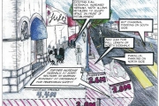
From a pedestrian’s point of view this would look like wider sidewalks on the north side of Columbia, with 2.2 metres being added to the existing 4 metre-wide spaces. Intersection bulbs would be constructed at each of the three main intersections as well. This would serve both as a traffic calming measure as well as a potential cure for Rossland’s love of downtown jaywalking. The intersection bulbs would cut the distance of the existing cross walks by as much as half, creating a safer environment for crossing the busy street.
Bikers could also get a safer route through the downtown area. The plan calls for two layouts that would alternate with the seasons. In the summer a two directional, dedicated bike lane would sit between the expanded north side sidewalk and reworked parallel parking stalls. In the winter, the bike lane would be used for 60 degree angled parking.
In addition to creating new and more functional pedestrian space, the report also looks at ways to retain and increase downtown parking.
One suggestion is to re-angle the parking stalls along the south side of Columbia Avenue to 60 degrees. This would create seven additional spaces in the same stretch of street.
More parking could be created behind the Nelson District Credit Union with improvements to the existing lot that would allow additional cars as well as downtown RV parking. As part of that plan, LeRoi Avenue would become a one way street. Even more off-street parking could potentially be created by grading and expanding the alley behind the north side of Columbia Avenue. With a retaining wall put in place, eleven additional spaces could be created, bringing the total number of slots back there to twenty two.
Throughout the design charette process, the most consistently received negative response was to the idea of installing parking meters. As part of the infrastructure work, electrical conduits for one parking meter machine per block are included in the design. This does not mean Rossland will have parking meters, only that the ability to install them in the future will be there.
On the other side of the story the most common positive response was to install more seating downtown.
Ultimately, which (if any) of the cosmetic improvements to our downtown get included in the final plan will come down to dollars and cents. For now, discussions between the city and the Ministry of Transportation are ongoing.


