And there shall be signs - new Rossland signs just the beginning

By Andrew Zwicker
Rossland has often been thought of as an invisible city when it comes to signage. However, during the past two weeks three giant leaps forward have been taken to changing that perception. Commissioned by Tourism Rossland in 2008, the “Way-finding signage strategy” is a five year project designed to improve the oriented directions signs in and around Rossland. The hope is to significantly improve tourism in town.
“In the past, much of our drive thru traffic did not deviate from the highways in order to visit our scenic downtown. By developing a cohesive signage strategy, we will improve the look and feel as well as the consistency of the theme of the town,” notes a report by Tourism Rossland.
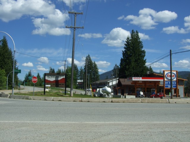
The first two signs in the strategy are now in place: one next to the Esso station at the City’s west entrance and one on the highway up from Trail near the Redstone entrance. These first two ‘monument’ signs are planned to be followed next summer by three additional ‘welcome’ signs. Smaller than the 3.6 meter wide monument signs, the welcome signs will be roughly 1.5 meters wide, will feature the same branding scheme as the first two and will read ‘Welcome to Rossland – Historic Downtown’ along with the distance to downtown. One sign will be located in the area of the Cascade Highway intersection as you come up from Patterson. The other two will be placed along Highway 3b with one just before the Mcleod Street intersection as you enter town and the other further out the highway, roughly at the first turn heading towards Rossland when you get a view of Red Mountain. The summer of 2012 will see the completion of the program with a kiosk style sign placed in Harry Lefevre square and four directional pedestrian banners placed throughout downtown. The kiosk will be four-sided and–although not confirmed yet–will likely include a detailed map of downtown businesses, a KCTS trail map, historical walking tour map, information and historical images. Sticking with the same branding throughout, the directional banners will point out locations of interest such as City Hall, The Library, the Miners’ Hall, and the museum. The banners will be placed at the intersections of Columbia and Spokane, Queen, and St. Paul as well as part way up the Washington Street block between Columbia and 1st Avenue.
In 2008, the five year project began with public consultation, a design committee and design work completed by Nowell2 Land Design. Through that process, a design manual was created and the job put out to tender. Initially, the construction of the first two signs was to take place in the summer of 2009; however, the sign manufacturers were tied up with Olympics-related work. This delayed Rossland’s project until the Spring of 2010.
All together, the signage strategy has been budgeted at $115,156.16 and is funded entirely by the Resort Municipality Tax Transfer program. The first two signs installed came in slightly under their $38,000 budget at $37,688.31.
Response to the location of the first sign near the Esso station has been mixed. In particular the location of the sign just beyond the intersection with Columbia and the proximity to the much larger Esso sign have dominated the discussion. With a goal of diverting more highway passersby into Rossland’s downtown core, comments received by the Telegraph have questioned if placing the sign beyond the intersection will do the trick and wondered how visible the sign is.
The final location of the sign was not the initial preferred location; however, forces beyond the City’s control led to the current site. While exact location of the sign was not specified in the design manual the first choice was on the north side of the highway before the intersection. One of the problems in that area, explained City engineer Mike Thomas, was that “Emcon does the snowplowing there they end up with quite large piles of snow that would be visible from the highway on that side. We picked a couple of locations on that side where it would be possible to put these signs, then we talked with highways (Ministry of Transportation) about it and they pretty much said no to all of the locations that we thought would work.” The Ministry of Transportation noted that any sign going on that side of the highway would require additional fences and/or guardrails to protect it. Such protection was not initially budgeted for. There was also the issue of getting electricity to the sign. The signage manual calls for high efficiency blue LED lighting to be placed on the underside of the top beam of the sign. Getting an electrical hookup to the north side of the highway would have added significant un-budgeted costs to the project. “To run a power line across a highway, or even 30 metres, gets well into the thousands of dollars,” explained Thomas. “On top of the cost of the signs, we weren’t real keen on having a location where there were additional cost issues.” Locating the sign in its current location was both OK’d by the ministry of transportation and provided a relatively-easy electrical connection.
See attached file for the signage manual detailed the project and showing images of the signs to come. What are your thoughts on the new signs? Their look? Location? And thoughts on the new signs to come?