City sits on a ticking time bomb of West Arm Provincial Park forest
The possibility of an evacuation in Nelson this summer due to the threat of wildfire is very real, with the city situated next to arguably one of the greatest fire risks in the province.
West Arm Provincial Park forest east of the city could set the stage for the next big B.C. blaze — and subsequent evacuation — as hot and dry conditions persist in the region with no sign of abating, prepping the tinder dry duff layered deep on the forest floor for ignition.
The forest is a ticking time bomb of our own making, with acres of long-protected wilderness contributing to huge tracts of undisturbed but combustible deadfall.
It shouldn’t come as a surprise: wildfire protection consultants have been warning of the fire danger to the Heritage city — posed by the 26,200-hectare forest that extends along the shore of Kootenay Lake from Nelson to Harrop and up to the peaks behind — for some time.
In December Bruce Blackwell of B.A. Blackwell and Associates Ltd. — a wildfire protection plan consulting company — said Nelson could be the next Fort McMurray if the risk of wildfire in the surrounding forest and the park was not reduced significantly in the near future.
At the time, Blackwell said the city had the unenviable distinction of being in the top 10 of the most fire-prone communities in B.C. and Alberta, according to his estimation.
And like the recent evacuations of Williams Lake, 100 Mile House and Princeton, the 1,500-hectare Harrop Creek fire currently burning south of Harrop-Procter means that near future could be now.
Blackwell had classified Fort McMurray as a low to moderate fire hazard risk — he did the plan for that city three months before a forest fire exploded last summer — and the city council of Fort McMurray ignored his recommendations.
“But I think Nelson faces a far greater risk,” he said. “And it’s not going to be easy to evacuate people in this part of the world. In fact, it’s going to be very complicated.”
The region’s topography makes fire fighting difficult, Blackwell said, and with only a few main roads to carry people away on, the bottleneck of an evacuation from an un-fightable fire would catastrophic and deadly
Nelson has a lot of “ignitions” throughout the summer as lightning strikes with regularity, Blackwell noted. And there is a forest fire fuel load here that is very high relative to other areas of the province.
“The risk to Nelson is significant, and it is partly due to the fact you live in a rainforest,” said John Cathro of Cathro Consulting, a wildfire protection plan consulting company based in Kaslo. “The forests do grow fast but they don’t stay wet all of the time and when they do get dry it becomes a real risk.”
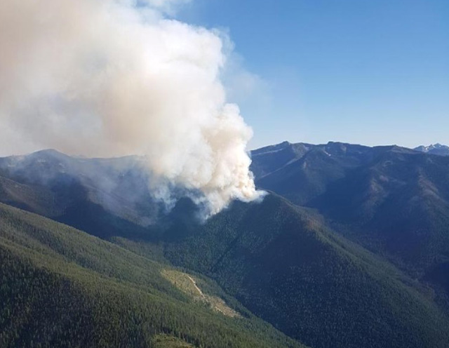
The risk is evident when observing the smoke hanging in the sky from the Harrop Creek wildfire.
The Southeast Fire Centre said Thursday while this fire is visible from surrounding communities, it is currently not threatening any communities or structures.
The fire, which has been burning since Thursday, July 27, is burning at an elevation of 2,000 metres.
As of Thursday, there are 33 firefighting personnel have set up a fireguard with the aid of heavy equipment and three helicopters. Crews are working on the south flank of the wildfire.
Attack crews were initially dispatched to the fire but because of the steep, rocky and inaccessible location of the fire, they were withdrawn for safety reasons. Because of the difficult terrain and smoky conditions, air tankers were not able to fight the wildfire effectively.
The significance of the Harrop Creek fire is not lost on many North and South shore residents.
“When one is looking at the South Shore in mostly its wildness, then switching tack and seeing the build up of homes and people on the North Shore, it is striking to see the enveloping forest, the lack of interface and the potential for grievous harm,” said North Shore resident Jay McKimm.
“It doesn’t take too much imagination to see what the incineration of our tight valley would look like, since we have historical photographs from the past, the 1800’s. Our fire suppression efforts over the recent 80 years have done unnatural reconstruction to the forest we live near and continue to settle deeper into. The protection of the South Shore forest and creating a park there is sure to come back and bite us.”
McKimm noted that the ecosystem of the area from shore to tree line is ripe for fire as it is laced with deadfall, from diseased and decayed to mature tree stands, it includes long dead lodgepole pine and more recent clump populations of Douglas fir.
There has been a recognition that the Forest Service was no longer capable of putting out all wildfires in all places, said Blackwell, so many communities like Nelson began to develop prevention strategies to protect communities.
The first Community Wildfire Protection Plan for Nelson was presented in 2008 and was part two of a larger plan for the regional district. The plan contained a number of recommendations that city staff have carried out since 2008.
The 2008 plan identified fuel treatment areas within city boundaries that have all been addressed. The updated CWPP for the city identified a number of FireSmart and wildfire reduction initiatives including “areas of interest” just outside of Nelson — such as the West Arm Provincial park — that presented significant risk to the city and proposed the city work with the regional district, B.C. Parks, utilities, licensees and others to reduce the risk.
Previous fuel treatment of 107 hectares has been accomplished, but the proposed areas of interest around the city comprise 887 ha.
Since the beginning of April the fire season has been heating up across the province, with over 4,200 square kilometres having been burned as the result of 840 fires — including 124 in the Southeast fire centre. As of Tuesday, 14 fires in the region were classified as out of control, with the 4,833-hectare Verdant Creek fire the largest.
And with hot, dry weather expected to increase over the next few days and no signs of moisture, smoke will continue to hang over most Kootenay communities and make matters worse.
Across the province there are still 6,000 people under evacuation order, while 138 fires continue to burn.
Already the fires have taken a toll on human structures across the province, including 71 homes, 116 outbuildings (sheds and barns) and three commercial buildings, according to Emergency Management B.C. Another 115 destroyed buildings were not identified.
The province is now pulling in some outside help for the fight — a total of 761 fire personnel from outside the province are in B.C. — along with 108 firefighters and support staff from Mexico.


