Flooding not expected for the Kettle, but high stream advisory issued

By Contributor
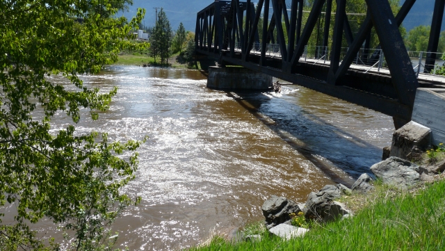
With the heavy rainfall over the past two days, and snow at higher elevations, the Boundary rivers are on a high stream advisory and others throughout the Kootenays and Okanagan are on flood watch.
The BC River Forecast Centre is upgrading the advisory to a flood watch for: Monashees including Eagle River, Shuswap River, Sicamous and surrounding area tributaries and is maintaining the flood watch for rivers in the Kootenay and Columbia Regions including: West Kootenay, East Kootenay, and Columbia (Illecillewaet, Kicking Horse and surrounding rivers).
The BC River Forecast Centre is maintaining a high streamflow advisory for rivers in the Interior including:
• South Interior/South Thompson Tributaries
• Okanagan‐Kettle
• North Thompson River.
A large‐scale upper low pressure system has developed across British Columbia and has delivered significant moisture across the province. Rainfall amounts in the past 48 hours have been in the 20‐40 mm range through the North Thompson and Okanagan‐Kettle region, and 40‐70 mm range in the Monashees. River levels have been rising in response to this precipitation and are forecast to continue to rise.
River levels are expected to continue to rise through Wednesday as rivers respond to heavier rain that fell last night and today. The low‐pressure system is expected to continue to develop through Tuesday evening and into Wednesday, with additional rainfall in the 10 to 30 mm range forecast overnight Tuesday.
Rises in river levels can be expected throughout the region into Thursday, and into Friday for larger river systems. Rivers in the Monashee region, including the Eagle River, Shuswap River, tributaries to Shuswap Lake and surrounding areas may reach flood level. There are reports of minor flooding issues in this area as of 2:00 p.m. Wednesday.
Other rivers in the region, including the North Thompson, Kettle, and Granby Rivers, and Mission Creek, may reach 2‐year flow levels, however major flooding is not expected at this time.
The River Forecast Centre will continue to monitor conditions and will provide updates as conditions warrant.
Definitions:
A High Streamflow Advisory means that river levels are rising or expected to rise rapidly, but that no major flooding is expected. Minor flooding in low-lying areas is possible.
A Flood Watch means that river levels are rising and will approach or may exceed bankfull. Flooding of areas adjacent to affected rivers may occur.